Mapalomalia lets geologists create and visualize 3D geological models from their browsers. It’s a free to use geological modeling platform. I hope people will use it to convey information about our planet that helps humankind to tackle big problems and at the same times makes geological modeling easier. I have developed it with input from many geologists, and by releasing it early I hope to receive more input from many more geologists. Just sign up here to start creating models.
Mapalomalia
With mapalomalia you can:
- Create or edit geological maps that always have a good topology.
- Create cross sections easily, which creates a solid model since the first section.
- Create visualizations with the cross sections interpolation: . It’s particularly easy to create a block diagram, just draw a polygon around it.
- Create interactive documents, linked with the visualizations, maps or cross sections.
See the here for more information about what you can do in mapalomalia.
Geological Modeling with Mapalomalia
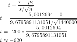
We’ll start with a geological model of my city, Medellín. We made it and gave it wave velocity properties to simulate a large earthquake. This is the default visualization for that model, it contains the geological map with the topography and all the cross sections. You can find the full study of Medellín here.
You can move it and browse it. You can also exaggerate the topography clicking in options, or click in any of the geological units to see its description and in the colorful point in the middle for a nice picture of my city.
INterpolations of cross sections
The most interesting feature about mapalomalia, besides its sharing capabilities, is its capability to create interpolations of cross sections even when the geology shows rapid changes in geometry and topology, which should make geological modeling faster.
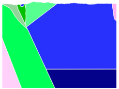
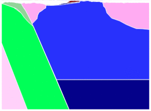
Here is a geology whose changes are small and only at the topography level. You can see that mapalomalia finds a smooth transition between the two cross sections, except when one of the features does not appear in the other cross section. For a better view, click here.
But what happens in the case where the geology changes abruptly? Should I start from scratch? That’s the case for which mapalomalia was created. Sometimes the geology changes abruptly, it’s not like when you are designing a car where you might make things more or less smooth so your CAD works well with it and the 3D printer prints. Modeling nature is a completely different story, so mapalomalia always gives you a solution, (bugs might happen, report them please!, we’ll take care of them). Mapalomalia will try to help you as much as possible, so the changes you have to make are minimal, and you have a really simple editor to do them, (I’m biased, but some people have learned to use it in minutes). See these interpolation of two cross sections from the same model, but the geometry and topology changed abruptly. For a better browsable view click here.
If we continued to show images from the last to the previous, we would see how, smoothly, the shape becomes the same. So, how do I create a new model? For a step by step tutorial for creating a geological model, go here. But if you need a quickstart, just:
- Create the study in your studies page.
- Georeference the model with a EPSG code and a bounding box, you can manually enter them or use the helpers available.
- Upload and select a topography, only GeoTIF is supported as of today.
- Click send, wait for the basemap to appear, Click to add an empty geology and then Send.
Voila, if you click in visualizations, and everything was OK, you will see a somewhat transparent topography. You then will have to start drawing the map or delete that geology and import one from a shapefile.
It’s all about the topography, right…
Talking about GeoTIF topography, on April 1, ASTER imagery became available. See the press release here: nasa jpl news. Topography had been available for long, but the old site where it was easy to download, was closed, however, a new site where’s even easier came to life!!! https://search.earthdata.nasa.gov/search. Not only DEMs are available, but imagery too. I also found that they upgraded the STRM DEMs to 1 arc degree. The same resolution as ASTER. I would have to check but I guess it also takes information from ASTER DEM. The difference between ASTER DEM 2 and STRM, at least for people who lives in tropical countries with great mountains and a lot of clouds like me, is that the old ASTER DEM had a lot of artifacts and peaks. I was actually going to make a tutorial about combining ASTER + STRM for a good DEM when I saw this. So now you don’t have an excuse to start using mapalomalia.