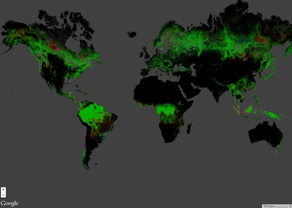
In my previous post I described the difficult process that led to the launch of Landsat-8. Here I will comment on the two sensors, the Operational Land Imager (OLI) and Thermal Infrared Sensor (TIRS), that comprise the sensor package on the Landsat-8 (L8) platform. This post will come across as highly critical, in some ways it is. I do want to point out though, at the start, that I appreciate the work of NASA and the USGS in securing the future of the Landsat programme: a program of global importance. In fact the programme has been so chaotic and ad hc that the Space Studies Board argued that it should not been seen as a programme at all.
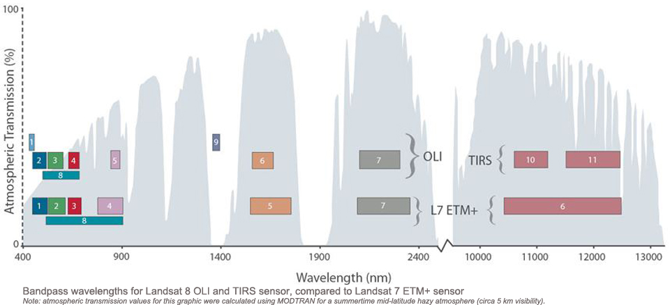
Irons and colleagues described the evolution of L8 starting with the Land Remote Sensing Policy Act of 1992. They pointed out that TIRS was developed in less than 3 years, leading to compromises. For example, the spatial resolution of TIRS data was worse than that of the thermal band of Landsat-7 ETM+: 100 m rather than 60 m. They deflect concerns by arguing that 100 m is sufficient for water measurements in the large fields of the midwest. Here it is important to comment that L8 is a US satellite, designed primarily to meet US needs. BUT, the US claims leadership in space and Earth Observation,as explicitly expressed in the Land Remote Sensing Policy Act. It is therefore appropriate to review the L8 platform from an international perspective.
TIRS: hurried and it shows
So we know that TIRS data has worse spatial resolution than ETM+ thermal imagery. However, TIRS does offer two bands in the thermal infrared, rather than one that ETM+ offered. TIRS out performs ETM+ in other ways. Data are transmitted at 12 rather than 8 bits leading to higher nominal radiometric resolution. TIRS saturates at 360-365 K as opposed to ETM+’s 345 K. The noise performance is significantly better on TIRS. However, currently USGS is advising against using band 11 of TIRS due to calibration issues.
TIRS however does not outperform other missions. The HyspIRI mission plan calls for four thermal bands saturating at 500 K; signifcantly better than TIRS. The HyspIRI thermal data will be collected over a wider swath, reducing revisit times. The Space Studies Board study of future land imaging calls fr reduced revisit times by using wider swaths and satellite constellations. 16 day revisit times are no longer considered sufficient for many applications, including operational soil moisture mapping. Wild fire and volcano monitoring would also benefit from higher temporal resolution. A 2009 review by Mary Pagnutti suggests many applications require revisit times of less than a week and a GSD of better than 100 m. Like the Space Studies Board she argues that leveraging small Low Earth Orbit satellite constellations increases revisit times. The SSB also argue that constellations improve system robustness.
But it is hard to discuss TIRS without returning to the biggest compromise made to include it on the L8 platform: the design life. A three year design life is simply hard to defend. If the argument for a thermal sensor was so convincing, then surely TIRS will be still needed after 2016? I wonder if a better, off the shelf solution to TIRS rapid development, could not have been attempted. A better option would have been to develop two small TIRS sensors, launched after the L8 platform flying in constellation. Such a configuration would reflect the design recommendations of the SSB and Pagnutti and would secure thermal imaging beyond 2016.
OLI: not bad, could be better
Landsat-8 has to balance the exploitation of new technologies to improve data quality, with the need to provide data continuity. OLI added two new bands to the Landsat legacy bands: an additional visible blue band for ocean colour/coastal marine applications and a cirrus band for improved cloud detection. OLI builds on experience with the EO-1 ALI instrument and other imagers. However, there is little evidence for an influence from Hyperion or AVIRIS in the OLI. The Near infrared (NIR) band is narrower than that of L7 ETM+, but there is only one NIR band. There is also no band around 1200 nm, which would be a useful complement to the Landsat legacy bands. In fact, with the cirrus band not design for land imaging OLI only adds one more band, band 1. This I think is a missed opportunity. Sentinel-2 in many ways will outperform the OLI. It will have more NIR bands, with higher GSDs and narrow bandwidths. The design life is 7.5 yrs and the fuel is budgeted for 12 yrs. The mid infrared is not covered by Sentinel-2 however.
Band 8, the panchromatic band, is significantly narrower on the OLI compared with ETM+. This means no pansharpening of the NIR band! This is apparently to “The OLI panchromatic band, band 8, is also narrower relative to the ETM + panchromatic band to create greater contrast between vegetated areas and surfaces without vegetation in panchromatic images”. However, this goal can be achieved through pansharpening of the NIR and the use of vegetation indexes, so I fail to see the logic of a narrow Pan band. Surely for Land cover/Land use studies a higher resolution NIR band is better than higher contrast in panchromatic imagery? The Band 8 GSD remains at 15 m; either due to the cost and difficulty of creating a detector array even longer than the 15 m GSD array or due to a need to avoid a political battle over a government sensor in competition with commerical very high resolution land imagers. Regardless, band 8 does not seem to be improved, to my way of thinking. Compared with the Sentinel-2 specifications (above), the OLI looks rather ordinary.
Summary: Landsat-9-12 must be better
The SSB report on the future of the Landsat programme asks whether it is time to evolve the Landsat concept into a constellation or system of systems, possibly involving commercial or international partners. NASA developed the A-train concept of satellites in constellation, by accident. Other nations already have satellite constellations for Earth surface imaging in operation (e.g Tandem-X, COSMO-SkyMed). Others, such as Sentinel-1 and -2 are in the pipeline.
THE lesson to be learned for Landsat-8 is that better forward planning is needed. The weaknesses I believe exist in the L8 sensor package are a function of a difficult evolution and implementation of the L8 mission, not limitations in NASA’s technical expertise or industrial capabilities. In some ways it seems the European Space Agency has been better at learning from the Landsat and SPOT programs than NASA and the USGS. The future Landsat platforms should leverage technologies to improve data and quality. The SSB recommends block buying to reduce costs: that is purchase the next three Landsat platforms in one go rather than an ad hoc purchasing plan. Getting more bang for the taxpayers buck! The SSB states that each block should evolve the technology so that blocks of satellites are identical (and cheaper) and the blocks evolve with the technology. According to this model L9-12 would be identical to each other but ‘better’ than L8 ; L13-16 would have evolved technologically from L9-12 but would again would be clones of each other. Here there are clear benefits including longer planning horizons. Better coordination between international partners should also help optimize land imaging, possibly through the Group on Earth Observation (GEO). Landsat-9 or 10 need not be seen as single missions in isolation but rather as part of a “Sustained and Enhance Land Imaging Program” to quote the SSB.
REFERENCE
Irons, J.R. et al. (2012) The next Landsat satellite: The Landsat Data Continuity Mission. Remote Sens. Envion.,122, 11-21. doi:10.1016/j.rse.2011.08.026

[…] Maps in Games: Battlefield 4 und Mapbox more articles Landsat-8: how not to plan a mission (Part 2: the sensors) […]