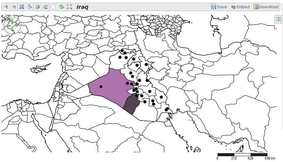
The “crucial” part: We only have a csv file with city names and attributes (incl. coordinates) and a kmz from Google Earth where we “digitized” provinces. The geo-aware people will probably download the same data from Natural Earth Data as shapefiles but a csv file and the work with Google Earth resulting in a kmz/kml file is quite common in the non-GIS world.
We will try to export the map as an image and try to embed into our blog post as an interactive map. As some mappers don’t have coordinates we will check geocoding possibilities as well.
Attention: This is not a professional, in-depth analysis of current webmapping platforms. Many of the “analyzed” platforms have much more functionality as we need. We don’t care if we cover everything and it is just our personal opinion.
ArcGIS Online
ArcGIS online is the web version of the well established ArcGIS software stack. It is developed by ESRI, located in Redlands US, (might be of interest if you plan to host more interesting data regarding so-called states of the “Axis of evil” ;-))After registration with an email address I was asked to create an account and an organization. Unfortunately ArcGIS.com does not tell you to use only letters and numbers in passwords (is this 1998????) so it took me a while to register for my 60 day trial period. After this it went quite smooth: Pressed “New Map”, click on “add+”, choose my csv file and 1-2-3 I got my map with a selectable basemap, my cities with labels and population-proportional circles (easy due to interaction menu on the layer in content and “change style”; sidenote: Fancy heatmaps are available to!).
But now comes the tricky part: sharing it on an own website. First I needed to check my layers and maps to be sharable with “everyone”. This was not straightforward especially not for the layer. After choosing “Share” I was presented with an iframe code to embed (see the map below) but I haven’t managed to see my cities right away. It seemed like it took about 20min to migrate the added layer into the databases of our friends at Redland. Only the basemap was presented first hand. Now you can see the city file below as well.
Additionally ArcGIS online does not support kmz files out of the box (see comments below) and I haven’t found any data especially for Iraq.
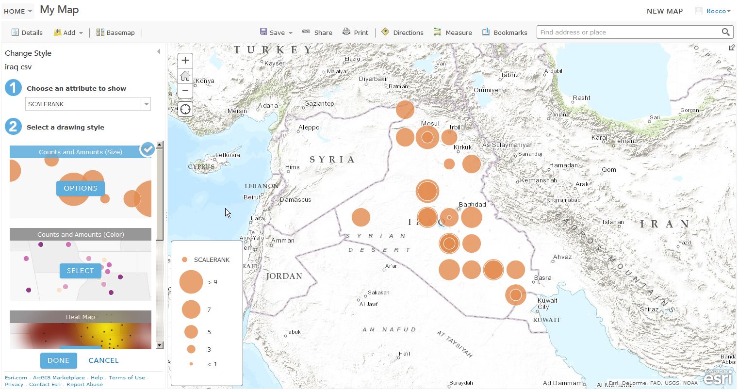
But I found an administrative boundaries data layer which I added. Unfortunately the positions were shifted against the basemap and were not in line with it in the end. ArcGIS online does not care about your decimal separator and rounds coordinates by default. After altering the csv and replacing comma by points I was in line with the basemap…
Wait! You said trial account? ArcGIS online requires a subscription plan. It is not easy to see a price tag for this but you can do the math: license is 500$ per year per user for a minimum of five users.
A nice possibility to work with is the presentation mode to quickly change between mapping frames and different content. It corresponds to the trend of “storytelling” with maps:
Pros
- probably the major on the GIS market
- online analysis of data
- immense functionality in style/stats/changing data
- presentation mode
- additional functionality by simple check boxes for the embedded webmap
- no kmz/kml support
- only paid subscriptions
- non-transparent pricing scheme
- complexity
CartoDB
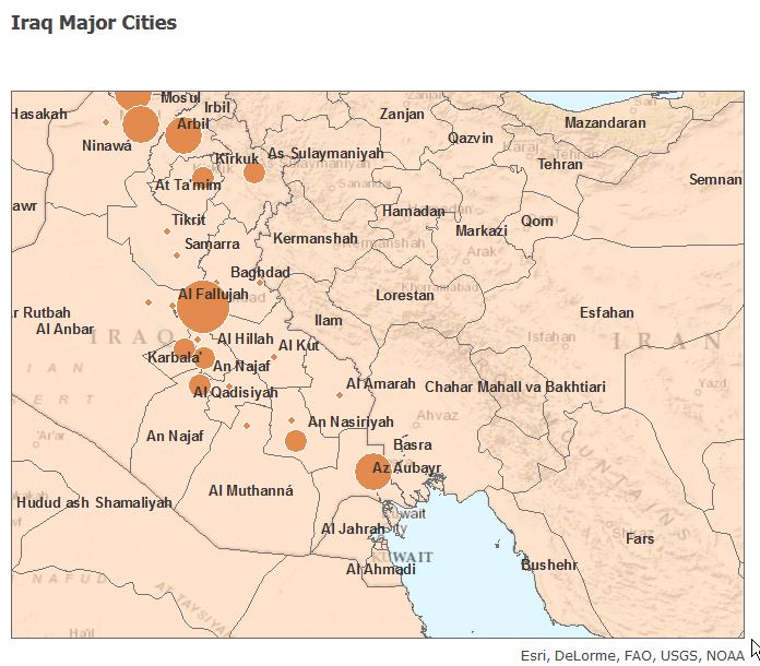
CartoDB (founded in 2011) is a portal with two main features: a table and a map. After the simple registration with name and email address you will have the possibility to take an english tour. You can also use some video tutorials that are displayed after pressing “new Map” to get an easy introduction to the mapping platform. As we know what we want to do, I choose Create New Map. Now you need to understand that “connect Dataset” means to upload one… But this is easy and you can select from different sources like google spreadsheets, dropbox or twitter… And cartodb seems intelligent and does not care whether you use comma or the dot as decimal separator. Additionally it also consumes kmz/kml files. The data is stored in a spatially enhanced table. You can add columns and new entries right away. It is quite easy to understand that the table is not part of the data it more or less defines the data which is part of the map. You can alter styles for all your features in an interactive menu on the side and switch between different styles, alter your legend, and you have much more options. Check this small speechless video:And check the embedded webmap here:
The best thing on cartodb? It’s free for the basic usage. The first level of plans with private data tables starts at about 150€. Compared to ArcGIS online the pricing scheme looks quite transparent.
Pros
- new and fresh design
- for free at a basic usage level
- great style customization through css
- image export is straight forward
- zip file support
- limited statistic features
- no easy labeling for points
- CSS not for the faint hearted
MapBox
Mapbox was also a little game changer as they opened the world for non-GIS people, designers and web developers. With their Tilemill studio it is easy to create your own basemap backgrounds and tiles. But what about the basic stuff? The registration was off course quite easy. But now the trouble starts. First: add the csv file as data failed miserably. I was not able to import my data straight away. After a while I figured out to use “,” as the separator after trying to alter field names, decimal separator, the order of the fields and so on. After I managed it I just needed to select the title and the description (not more than one field allowed :-/ ) The import of the kmz was not supported so I needed to extract the kmz to a kml and add it.Furthermore there are no labels adjustable and also the popup was only customizable on a feature basis. The CSV was treated not as a layer. Instead every entry in my csv was imported as a separate feature. that was not very easy to customize as you needed to design the popup for every city :-(. If you want to add a csv file as part of a data storage you need a basic plan which means a subscription at a basis of 5$ per month. That said I found the possibilities which you can use in the online editor quite limited. I am aware of their great API and developments like turf and also some great basemap designs.
Pros
- great for developers (API, js libraries, etc.)
- great for designers (Mapbox Studio, tilemill creator, etc.)
- nice portfolio of basemaps
- no basic data storage
- no trial for paid service
- hard to work with
SimpleMappr
SimpleMappr is quite an easy tool. No registration is needed (but you can, to save your maps); just upload your data and that’s it. Don’t expect to much. After altering my file heavily, I was able to add my point data. But they provide example files as a guideline which helped a lot. The interface offers simple check boxes what you would like to see on the map besides the uploaded points: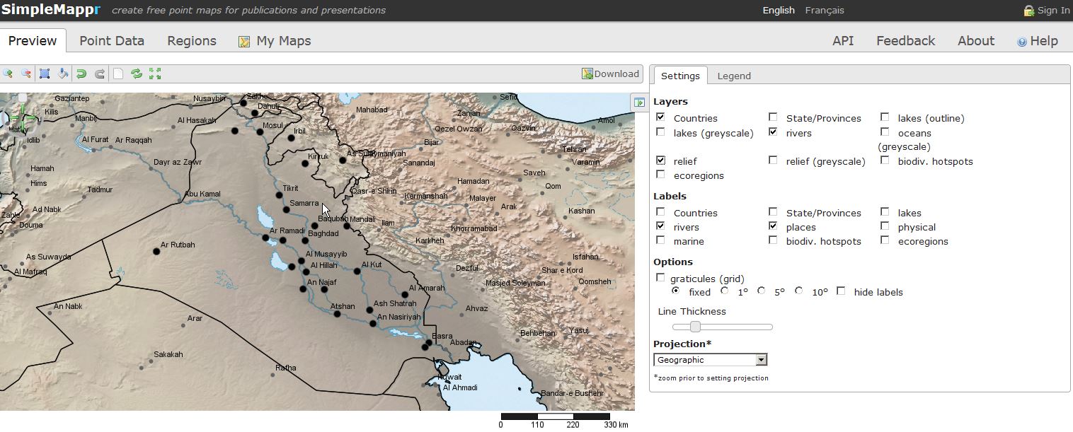
Pros
- lightweight
- storeable json/kml
- interactive color selector
- no real embedded webmap
- small functionality
- no scaling of markers
Mangomap
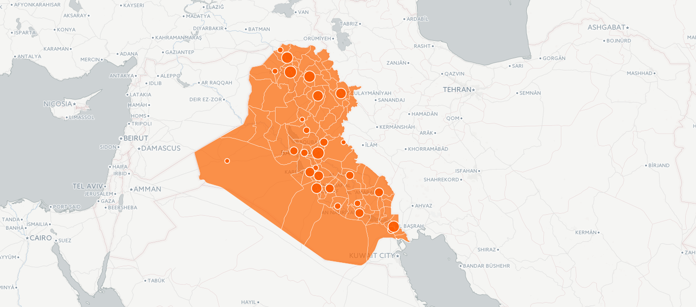
“Make a map – it’s free” – I followed that slogan in order to map our sample data with mango maps. First you have to do a fast sign up process on Mango Maps and the mapping starts immediately. Mango Maps offers four levels of map customization: 1. Customize the theme and layout of your map 2. Upload data and create visualizations 3. Enhance your map with additional tools 4. Decide who has access Luckily Mango Maps offers all common data formats for uploading map data (Shapefile, KML, File GeoDatabase, GeoTIFF, CSV, GeoJSON, MapINFO, WMS) so the upload of our csv iraq-data worked without any problems. The KML must be saved as KMZ.


Pros
- easy for beginners
- fast map production
- good map app performance
- no KML support
Click2Map
As with all the other services the registration wasn’t a hazzle. Click2Map is an online service which is based on probably the google maps API. It’s easy to import my cities and they are all shown nicely at the correct locations. You can also upload other formats and you just need to a mapping of headers in the input file to categories/attributes of the click2map marker. Unfortunately it seems not able to upload a kmz/kml. And after playing around with drawing a polygon (nice possibility also offered by lots of the other platforms described here) the page freezed…
And I was not able to rebuild the map again, yet my markers (which are customizable) were still there. You can’t embed a map right away but you can download the current map as a zip which holds everything you need to host it by yourself:
If you want to host your map, it’s 39$ per month or 390$ per year.
Pros
- standard technology (Google Maps)
- downloadable webmap as zip
- upload for custom markers
- no KML support
- crashed right away
- no scaling of markers
If you have trouble with creating a webmap for your needs, just contact us for professional support.


😉 missing uMap (https://umap.openstreetmap.fr/it/) and … Google
uMap… I might add this in a while.
@Jakob will write a follow up with 5 more services (alongside with umap, which is awesome!)
using kml in arcgis online:
http://blogs.esri.com/esri/arcgis/2013/07/29/using-kml-in-arcgis-online-web-maps/
but you need to place the kml on some webserver and can’t use it from local.
Saying there is “no kmz/kml support” as you have listed in your “cons” section is misleading and simply wrong.
It’s true that it doesn’t have the same “drag and drop” functionality like a CSV file. But you can take a local KML file and upload it as an “item” to your ArcGIS Online content. You can then simply open the item as its own new map or add it to an existing map.
More details here on how exactly it works: https://doc.arcgis.com/en/arcgis-online/reference/kml.htm.
Feel free to try it out and/or correct the record.
Hi, you foget Gis CLoud, its work very nice 2 me
We’ll write about this in the part 2 article!
BTW, you can use an ArcGIS Online Developer Subscription to do all that for free. You get 50 credits a month (forever, no limited trial), which is plenty for what you’re talking about. Head over to https://developers.arcgis.com, sign up there, and then use that account to log in at https://www.arcgis.com. Hope that helps!
And ArcGIS Online supports KML!
You missed Google Fusion Tables and Google My Maps. Or, grab some free map vectors and try your hand at making a map of your own!
You can upload a CSV and add custom markers and labeling using Mapbox Studio. Also small edit you also called it “TileMill Studio”. Here is a tutorial on loading CSV data and editing the labeling for the points. https://www.mapbox.com/guides/source-quickstart/
UIZ has started to develop – EMAIV
http://uizentrum.de/en/environmental-monitoring-analysis-and-interactive-visualization-emaiv/
Thanks for including MangoMap. Just to clarify, MangoMap does support KML files, but does not support the compressed KMZ archive format: http://docs.mangomap.com/knowledge_base/topics/uploading-kml
Why not to conclude OpenGeo suite form Boundless?
I think it’s a combination of offline desktop tools.
Another one that might be of interest is AmigoCloud – maybe it is more of a cloud GIS than just a map maker, but interesting for sure!
Thank you very much. It is useful
great article !
I want to add that I like in Mapbox the possibility to export the map for printing.
Nice idea for a quick comparison, but there are a BUNCH of typos/missing punctuation. It makes your critical review less credible.
Hi To Pa Lu,
thanks for your feedback. We’re grateful for every hint. Could you please send your suggestion for improvement to info@digital-geography.com ? Also we happily invite you to help us as a lector.
why not leaflet?
Consider including Data Basin (http://databasin.org/) in your review.
Check http://www.uebermaps.com , widely used by communities and bloggers to share local information collaboratively, eg.:
Social Hops Growing:
https://uebermaps.com/maps/2732-social-hops-growing-locations-
Whiskey Map of Scotland:
https://uebermaps.com/maps/2708-whisky-distilleries-scotland
etc. …